Backwater portions of the trail are serene and the scenery is often described as primeval.
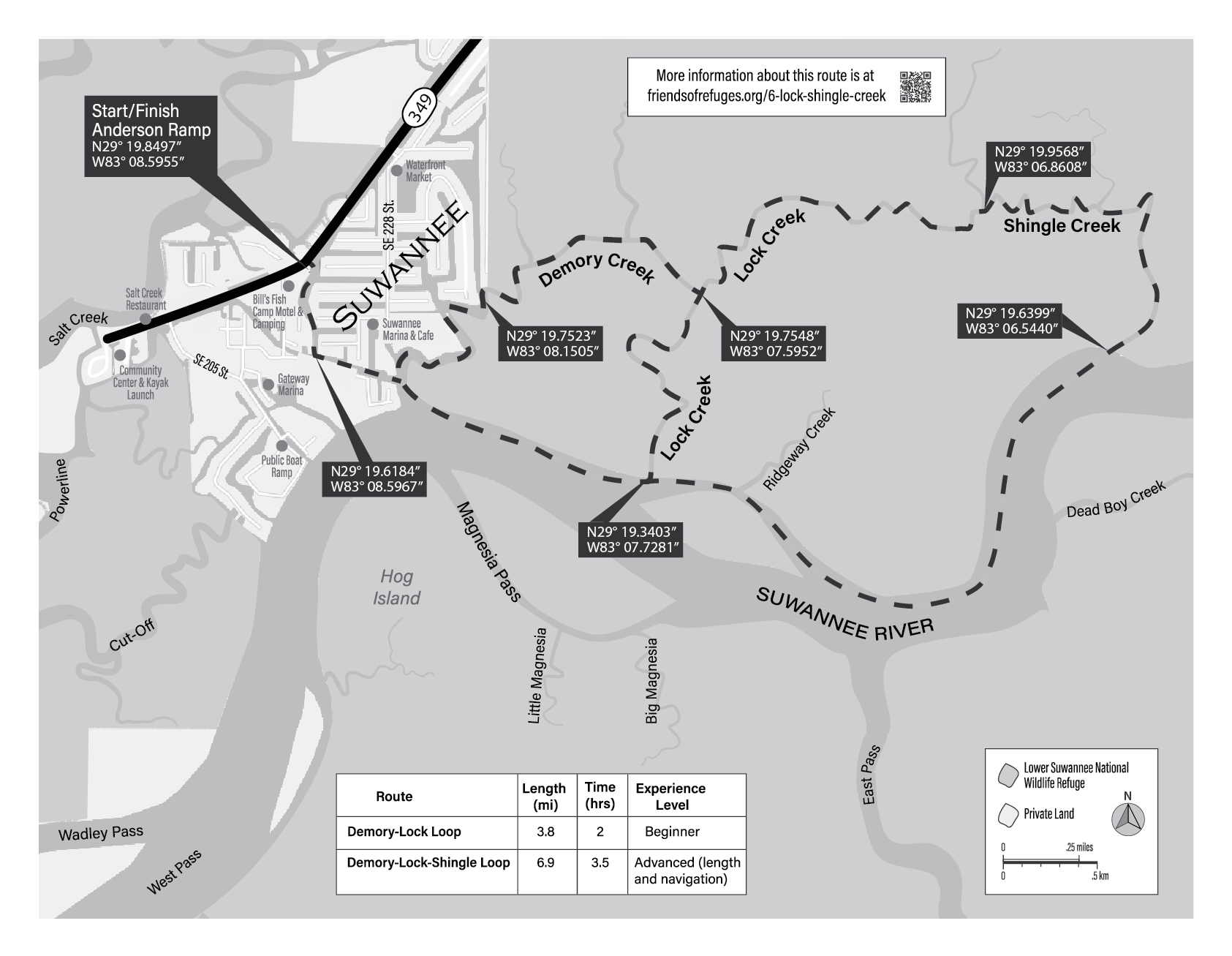
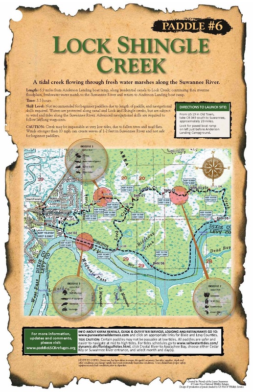
Lock, Shingle and Demory creeks are part of a paddling trail maintained by the Lower Suwannee National Wildlife Refuge, a unit of the U.S. National Wildlife Refuge System.
Lock, Shingle and Demory creeks are part of a paddling trail maintained by the Lower Suwannee National Wildlife Refuge, a unit of the U.S. National Wildlife Refuge System.
Length: 6.9 miles or 3.8 miles if you only paddle the Lock Creek loop.
Time: 3.5 hours for the 6.9 mile route.
Skill Level: Not recommended for beginner paddlers due to length of paddle and navigational skills required. Waters are protected from wind along canals and Lock and Shingle creeks, but are subject to wind and tides
along the wide Suwannee River.
Directions to the Launch Site: Once you have entered the community of Suwannee, look for the paved boat ramp on the left.
NOTE: The creek banks are muddy with dense vegetation, it is difficult to disembark along this loop. Sand gnats can be fierce unless there is a nice breeze.
BIOZONE 1: DEMORY AND LOCK CREEKS
Possibly the most alluring Suwannee paddle traverses small creeks off the river that wind through swamps and marshes. Light filtered through the leaves of tupelos, ashes and swamp bay casts an enchanted glow on a surprising variety of wildflowers. Fishes and alligators are abundant here, but this is the true haunt of wood ducks, river otters and turtles— as many as 13 species of freshwater turtles may be found in the Suwannee, including a distinct species of Alligator Snapping Turtle, Macrochelys suwanniensis, that is unique to the Suwannee drainage. The largest freshwater turtles in North America, alligator snappers can live for a century and grow to 200 pounds.
BIOZONE 2: FRESHWATER MARSH
Shallow backwaters of the Suwannee are often covered by vegetation characteristic of ponds or marshes such as spatterdock. Sawgrass and wild rice occupy patches in still shallower areas and, like spatterdock, add to habitat diversity. More importantly, the leaves and seeds of these these plants provide food for ducks and other wildlife.
BIOZONE 3: THE SUWANNEE RIVER
The parts of the Suwannee flowing through the refuge are mostly freshwater, but tidally influenced with the heavy saltwater wedging under the fresh. The regularity and degree of the twice-daily flooding greatly affects the vegetation; bald cypress, tupelo and pumpkin ash dominate these swamp areas. Farther inland bottomland hardwood forests take over. The Gulf Sturgeon may be seen in the Suwannee and in few other
rivers. It is an ancient fish that may reach 8 feet in length and weigh 200 pounds. They are found in the Suwannee in spring and summer, and may be seen making spectacular jumps out of the water. A less frequently seen animal is the West Indian manatee. Manatees may be seen near the mouth and outside the river during warmer months, and typically move into warmer spring runs in the winter.
SPOTLIGHT: BALD CYPRESS
Bald cypress is emblematic of southern swamplands. Living for hundreds of years and growing to enormous size, their one tragic flaw is the great value of their wood. Soft, light and resistant to decay, it has been relentlessly sought after. Specialized for periodic flooding, cypress knees are thought to provide carbon dioxide and oxygen to roots. The height of knees is often an indicator of the average heights of floods.
No GPS? No problem.
|
Use your mobile phone to track your location even if you are in an area without cell coverage.
|
| ||
Friends of the Lower Suwannee & Cedar Keys National Wildlife Refuges
P. O. Box 532 Cedar Key, FL 32625 [email protected] We are a 501(c)(3) nonprofit organization. |
|