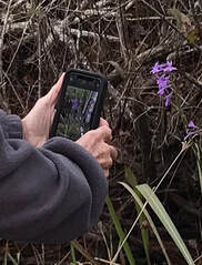
What is that?! Ever been on a hike at one of our refuges and come across a new and interesting creature or plant? Snap a pic on your phone and upload it to iNaturalist, it will identify things along the trail. A clear photo of the plant or animal will often be identified for you instantly. iNaturalist suggests a species identification, then other users who are familiar with the species can confirm. Add location and date information to a confirmed species and you’ve got a “research-grade” observation. Here is a detailed guide for how to get started. Just like that, you can collect data and become a citizen scientist for our refuges.
We need to know what’s out there so we can protect it. Data collection is at the heart of conservation. Photo documentation is a great way to collect quality data about plants, animals, insects and all other living things found on our lands. iNaturalist combines the photos and the data about them - date and location of observation, species identification, native range or protected status - to create a powerful conservation tool. You can contribute to future conservation efforts by helping build a bigger database of identified species on wildlife refuges. We can use your data to direct conservation efforts where they’re needed most. For example, if we know the location of a small patch of invasive non-native species, we can stop it’s spread early and help keep the ecosystem in balance.
There are many ways to apply this easy to use tool.
Check out the latest observations made at Lower Suwannee and Cedar Key.
Concerned about collectors? You can hide the location or your observation.
Trouble getting a cell signal while on the refuge? Please tell your service provider, advocacy is the only way we will get better signal strength.
We need to know what’s out there so we can protect it. Data collection is at the heart of conservation. Photo documentation is a great way to collect quality data about plants, animals, insects and all other living things found on our lands. iNaturalist combines the photos and the data about them - date and location of observation, species identification, native range or protected status - to create a powerful conservation tool. You can contribute to future conservation efforts by helping build a bigger database of identified species on wildlife refuges. We can use your data to direct conservation efforts where they’re needed most. For example, if we know the location of a small patch of invasive non-native species, we can stop it’s spread early and help keep the ecosystem in balance.
There are many ways to apply this easy to use tool.
- Use iNaturalist to explore our refuges before your next trip. Learning the names and stories of creatures you might find brings a deeper context to your explorations.
- Combining tech and nature is a great way to engage the whole family while you’re out on the trail. Your iNaturalist entries are like a natural history journal of your trip.
Check out the latest observations made at Lower Suwannee and Cedar Key.
Concerned about collectors? You can hide the location or your observation.
Trouble getting a cell signal while on the refuge? Please tell your service provider, advocacy is the only way we will get better signal strength.


